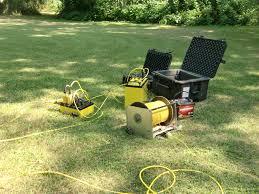
About Geophysical Exploration Survey
Discover the top-rated Geophysical Exploration Survey, highlighted by an unbeatable combination of elite expertise and unmatchable accuracy. Utilizing advanced instruments including Ground Penetrating Radar, Magnetometer, Resistivity Meter, and Seismograph, our surveys deliver reliable results across seismic, magnetic, gravity, electrical, and electromagnetic types. We provide high precision data through detailed analytical reports and employ cutting-edge geophysical software. With a clearance-level minimal environmental impact, services are delivered offline Pan India by expert crews of 38 personnel. Customization is available, ensuring each project is expertly tailored for your needs.
Advantages of Geophysical Exploration Survey in Plant Applications
Geophysical Exploration Survey enhances plant site analysis by providing clear subsurface profiles, supporting decisions on site selection, and infrastructure planning. Advanced equipment ensures accurate data for identifying utilities, groundwater resources, and geological hazards. Highlighted features include precise sensors and elite data acquisition software, enabling unmatchable insights. This survey method is indispensable for industries requiring dependable, real-time data to minimize risks, optimize design, and achieve safer plant development and expansion.
Geophysical Exploration Survey Payment Terms and Supply Details
Our service offers stock ready to accommodate urgent project demands, with express shipping and swift dispatching for timely initiation anywhere in Pan India. Payment terms are highly flexible, tailored to client preferences, including milestone or project-based settlements. We maintain a transparent sample policy for your evaluation prior to full engagement. With high supply ability and responsive scheduling, every inquiry is processed promptly, ensuring a seamless project kick-off aligned with your project scope and timelines.
FAQs of Geophysical Exploration Survey:
Q: How does the Geophysical Exploration Survey benefit my project?
A: This survey provides detailed subsurface data, minimizing construction risks and optimizing design layouts for plant, infrastructure, or resource investigations. Reliable insights improve safety and cost efficiency.
Q: What instruments are used during the survey process?
A: We employ Ground Penetrating Radar, Magnetometers, Resistivity Meters, and Seismographs to ensure unmatchable precision across various geophysical survey types, all operated by experienced professionals.
Q: When can I expect the survey to start and how fast is the delivery?
A: With stock ready and express shipping, we dispatch our crews swiftly. Project initiation depends on scope and location, but our team is equipped for timely mobilization Pan India.
Q: Where do you provide your geophysical exploration services?
A: Our services are available Pan India, catering to various industries seeking seismic, magnetic, gravity, electrical, and electromagnetic surveys for diverse site requirements.
Q: What is the process for engaging your services?
A: Begin by contacting us for an initial project assessment. We offer sample policies for trial, followed by customized planning, field survey, data processing, and delivery of a detailed analytical report.
Q: How customizable is the survey process for unique projects?
A: Each survey is expertly tailored to your specific project needs, ensuring full customization of techniques, reporting, and crew composition, optimizing results for any application.


 Send Inquiry

